Showing posts with label Hiking. Show all posts

Tuesday, August 25, 2020

Valles Caldera and the National Park System

Valles Caldera National Preserve, abutting Bandelier National Monument to the north, was formed by the collapse of the “caldera” of an ancient volcano about 1.25 million years ago. Today it appears, magically out of nowhere as one drives up winding roads in the Jemez Mountains from Los Alamos, NM, winding through forests of Ponderosa pine at over 8000 feet, and then, on your right, an immense grassland without trees but with wooded hills dotted across it, lava domes created somewhat later. This is Valle Grande, the southern and most accessible part of the Preserve, which is much larger. One can access some of it on dirt roads, and requires a back-country permit. A mile from the entrance, reached by a road where ones car is improbably surrounded by bluebirds, making it seem as if you are driving through the introduction of a Disney cartoon movie, is the visitor’s center, today staffed by mask wearing Americorps volunteers as well as a ranger who were happy to provide information from a safe distance.

 
Our first stop was the restroom facilities, an outhouse that would not be worth mentioning if it were not for the fact that between the two doors, under the peak of the roof, was a bluebird nest with little fledglings looking out, waiting for their mother to return with lunch!


There are a few relatively short trails near the “front” that one can take dogs on. The closest, which we did, is called the La Jara trail, appropriate as it circles the Cerro La Jara, just west of the visitor center. It starts off through a large prairie dog village to the north of the cerro, and is dotted with wild (elk and coyote) and more domestic (cow and horse) scat. It is supposed to be 1.4 miles, but can be longer if one loses it (it is a trail marked through grassland by the traffic of hikers only, and it seems they have been fewer recently) and heads off instead on the track that goes north toward the Cabin District (old ranching cabins). At some point you decide that you have gone too far past the Cerro and need to make your way back and find the trail. This is easy to do as it is flat grassland. Well, it is easy to see where you need to go. In fact, the grass hides not only uneven ground but occasional marshes…

 The hike is not at all difficult, flat and short, but it is entirely open without shade and even at 8500 feet it is sunny. Especially when you take your mask off for the hike and it not only no longer protects your nose, but it has apparently rubbed off the sunscreen you so meticulously applied, something you notice on looking in a mirror on your return. And, of course, while we are pretty acclimatized to the altitude having spent a month already at nearly 7000 feet outside Santa Fe, that haze in the air is smoke from the Medio fire northeast of Santa Fe (and a new smaller one in the Jemez to the south, plus smoke blowing down from fires in Colorado) and does make breathing a bit tougher and riskier, so we’re glad we haven’t gone on one of the longer hikes.

I have realized that taking photos outside with one’s phone is a crapshoot, since any appreciable amount of sunlight makes it impossible to see what is on the screen. So my panoramic video of the Valle Grande is mostly sky. However, here are two pictures that capture a little of what the valle and cerros look like.


 I think it is also worth noting that, while having Americorps volunteers and young folks (meagerly) paid by a conservation foundation assisting the rangers is good, it is not as good as having enough rangers and enough resources to make the most of the magical lands that are the US National Park System. Our federal budget for the National Parks should be enormously increased. They should not have to depend upon increasing user fees (although these fees are suspended during the pandemic). They belong to all of us and their maintenance should be paid for by our taxes so that they can shine as the gems they are. Expecting them to be “self-supporting” or not “money losers” is not only absurd, it is an insane inversion of what our federal dollars should be paying for. Indeed, it is just as absurd as saying the US Postal Service is “losing money”! This is another area that, 180 degrees opposite from what the administration is doing, should have vastly enhanced support. And, of course, a third, less popular, federal agency that needs its budget hugely enhanced is the Internal Revenue Service, so it can ensure that billionaires and corporations do not continue to evade paying their taxes as they do now. I absolutely support laws increasing the taxes they should pay, but right now I would be satisfied with their paying the taxes legally due from them!

https://www.theguardian.com/world/2020/apr/15/tax-change-coronavirus-stimulus-act-millionaires-billionaires

https://finance.yahoo.com/news/corporations-paid-91-billion-less-in-taxes-in-2018-under-trumps-tax-law-160745447.html


Friday, June 12, 2020

Fire in the Santa Catalinas


I live in Tucson, Arizona. For the last week, early June 2020, a wildfire has been raging in the Santa Catalina Mountains just north of the city. Tucson is surrounded by mountains, which makes it both beautiful and a wonderful place to go outdoors; hikes abound at all skill levels. The Catalinas are, to many including me, the iconic Tucson mountain range. They are close and they dominate the skyline. The “Foothills” of the Catalinas are the wealthy part of town, with often stunning views back down to the city and the other ranges, the Rincons to the east and the Santa Ritas to the south, and the Tucson Mountains to the west (which are also close in, but much smaller). The highest peak in the Catalinas, Mount Lemmon, at over 9000 feet, is accessible by car, and there is even a community, Summerhaven, near the peak. Some folks live there year-round but most have, well, a summer haven from the heat of the desert (highs in the 105 area this week). There is a wintertime downhill skiing area (one of only 3 in Arizona). There are many hiking trails, up there and on the road up. Sabino Canyon, leading into the mountains in the east, is a National Park, with a road (now limited to trams) up to the top, crossing the creek back and forth, from which trails spread out into the mountains, day hikes, backpacking, even up to the top if you’re fit and dedicated. My point is that the Catalina Mountains are part of the essence of Tucson, probably the natural feature most associated with our town.

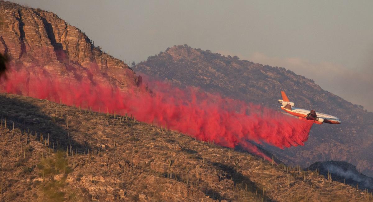
And now they are burning. Less than a week ago, on a Friday night, we could see the flames of the then-much-smaller fire, called the Bighorn Fire because it started on Bighorn Mountain to the west of the view we see from the city. On Saturday, a friend who lives in the northwest close to that area showed me photos and videos of planes – smaller spotter planes and helicopters and huge cargo planes -- piloted by brave pilot firefighters flying within 100 feet of the mountains to drop orange fire retardant. Firefighters and hotshot teams were brought in, but the fire continued to spread, from 200 to 2300 to now 3700 acres [update: passed 7,000 acres, 10% contained]. For a couple of days, planes could not fly, not because of weather but because of a moron flying his own private drones in the area which endangered them. Last night the flames of the original fire looked small as the blaze was now visible across most of the front range, and this morning smoke covers it all. More and more units are being brought in, but it appears as if, unless the summer monsoon rains start soon – and there is no indication that they will – the fire will continue to spread, including down into the canyons like Pima and Finger Rock which are major hiking routes. And it will certainly threaten the houses built up highest in the foothills. Those houses shouldn’t be there, they should never have been built as they are right up to the border of the National Forest (which, fortunately, protects them from being built even higher); one of the more galling hiking experience to Tucsonans for many years now has been that the beautiful Pima Canyon hike begins with a half-mile trek between cyclone fences through a private development. But although they should not be there, the people who live in them should not have to lose their homes and possessions (and of course, we most importantly hope, lives).

When I was in college at Cornell, more than 50 years ago, I was in a dorm fire in which 9 people died. As we escaped that night, the smell of smoke was everywhere, and when I came back to my room it had saturated everything. I still smell that smoke; it was a toxic, petroleum based smoke from burning naugahyde and smells much different from the lovely wood smoke of fireplaces in the winter. But still, at bottom, smoke is smoke, and now as smoke fills the air, threatening to make it more difficult to breathe while outside (and, of course, in this COVID-19 epidemic, N-95 masks have not been available for months, and if they are should go to health workers), the memories are getting more and more vivid.

Bighorn Fire - ArizonaThere have been fires in the Catalinas before. Ten years ago, much of Summerhaven was burned, and the ruined forest is still visible up there. Firefighters have some hope that this fire will become limited as it burns into that already-thinned area. Where the current fires are burning, there has not been fire for a century, and fire is a natural part of the natural cycle. The bighorn sheep on Bighorn Peak and Pusch Ridge that have been re-introduced to supplement a dwindling herd will survive. They can escape the flames. The mountains, eternal as they are, will survive, thinned out. The fire was – this time – started by lightning, not people. But it is people who built so close, and people who will suffer, and our trails will be closed, and the beauty compromised.

And the smell of the smoke will linger.

Sunday, August 13, 2017

Hiking and dogs near Santa Fe


Lovely hike this morning, repeating the one of 2 days ago but earlier, just after sunrise, had coffee and breakfast after the dawn (see pic). It still got too warm for long-sleeve T after a while (though nice in the shade coming down the western slope of the hill). About 3 miles along ridges and valleys and down hills, past where the village of Trenza may someday be. The desert is so green from all the rain, it is almost a different place. Yesterday morning the rain, which is sometimes morning and sometimes afternoon, was threatening and it was still very wet from the rain of the previous afternoon and evening, so we took two shorter walks of about a mile, still getting a little wet and muddy, the dogs needing to be toweled off before coming into the small house and lying on “their” couch. The rain is much needed for some relief from the long droughts, and has usually been only part of the day, leaving us time to hike.

But that mud, from the trail, was nothing like yesterday afternoon, at least not for Fry. Despite the foggy, overcast morning, it cleared up and about 3 we took off along the ridge, around it, and down to just above the Cowboy Shack, where we head left for home across the valley. Well, at least Maggie and I did. Maggie had been drinking from the little canvas dog water bowl each time we stopped and I took some water, but not Fry. He was too good for that! Or maybe he had something else in mind. When we got to that turn, Maggie and I drank and went left while Fry trotted off to the right. He knew where he was going, and I did too, but there was nothing I could do about it. Down a little bit to the right, just before the Cowboy Shack, is a windmill-fed water tank; for cattle in the old days, now mostly horses. And, in the past, for dogs when we went further than there was water in the pack. Fortunately, Maggie has never done that, but Fry remembered.

So Maggie and I headed off and figured Fry eventually would catch up, which he eventually did (although not before I wondered if he might not find us, silly me, and I’d have to drive down and see if he was waiting near the closest road). And covered in mud, over all his legs, butt, and belly (pic). The water tank often overflows with mud around it at all the access points, especially when it’s been raining, which it has. It was a nice walk back, but back at the house I had to hook up the hose (and get something
on my arm from the grass that caused it to itch, but seemed to wash off) and hose him down. And then rub him down from a bucket to get the places I missed or couldn’t get too. And then he had to sit out on the deck for a couple of hours (in the shade, with a water bowl, and he likes it anyway) getting mostly dry before being toweled off and let in. What are the odds he learned a lesson? I wouldn’t bet on it! He didn’t take any water when Maggie and I did on this morning’s shorter hike, but fortunately (for me) there was no water tank, and he loaded up when he got home. If it stays clear, we might go on a hike that takes us by a different water tank this afternoon, so we’ll see…

In any case, the desert around Santa Fe is always beautiful, and maybe more so from all the rain (although fewer sunsets). The town is great; have had several lunches with friends (or sometimes alone) at favorite venues. Enough time for reading, writing, naps, and just enjoying the views. Sigh. Terrific!


Roadrunner vs Cooper's hawk: A real life "Discovery Channel" moment!

Amazing things happen in nature, as any viewer of the Discovery channel can attest. I am not personally a viewer of that channel, but have s...